


Sortie à vélo l'après-midi

pierrol
User
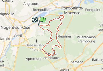

Length
28 km

Max alt
148 m

Uphill gradient
420 m
Km-Effort
34 km

Min alt
37 m

Downhill gradient
425 m
Boucle
Yes
Creation date :
2021-03-24 19:50:40.756
Updated on :
2021-03-24 21:18:16.37
2h19
Difficulty : Difficult

FREE GPS app for hiking
 SityTrail
IGN / Geographical institutes
SityTrail Plus
The world is yours!
About
Trail Mountain bike of 28 km to be discovered at Hauts-de-France, Oise, Verneuil-en-Halatte. This trail is proposed by pierrol.
Positioning
Country:
France
Region :
Hauts-de-France
Department/Province :
Oise
Municipality :
Verneuil-en-Halatte
Location:
Unknown
Start:(Dec)
Start:(UTM)
465427 ; 5458270 (31U) N.
Comments