


SityTrail - Col de Cabus

c.chehere
User
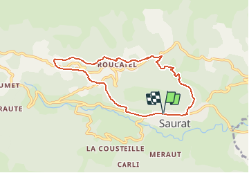

Length
8 km

Max alt
1081 m

Uphill gradient
438 m
Km-Effort
13.8 km

Min alt
670 m

Downhill gradient
436 m
Boucle
Yes
Creation date :
2021-03-25 04:57:12.979
Updated on :
2021-03-25 05:00:04.221
3h08
Difficulty : Difficult

FREE GPS app for hiking
 SityTrail
IGN / Geographical institutes
SityTrail Plus
The world is yours!
About
Trail Walking of 8 km to be discovered at Occitania, Ariège, Saurat. This trail is proposed by c.chehere.
Description
Parking à Saurat
Positioning
Country:
France
Region :
Occitania
Department/Province :
Ariège
Municipality :
Saurat
Location:
Unknown
Start:(Dec)
Start:(UTM)
380226 ; 4748365 (31T) N.
Comments