


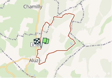
Rando d’Aubigny

jpbus
User

Length
7.2 km

Max alt
408 m

Uphill gradient
170 m
Km-Effort
9.4 km

Min alt
270 m

Downhill gradient
173 m
Boucle
Yes
Creation date :
2021-03-25 13:13:36.0
Updated on :
2021-03-25 15:12:48.566
2h00
Difficulty : Very easy

FREE GPS app for hiking
 SityTrail
IGN / Geographical institutes
SityTrail Plus
The world is yours!
About
Trail Walking of 7.2 km to be discovered at Bourgogne-Franche-Comté, Saône-et-Loire, Aluze. This trail is proposed by jpbus.
Positioning
Country:
France
Region :
Bourgogne-Franche-Comté
Department/Province :
Saône-et-Loire
Municipality :
Aluze
Location:
Unknown
Start:(Dec)
Start:(UTM)
628753 ; 5190078 (31T) N.
Comments