


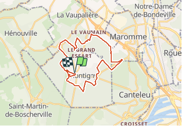
montigny 124

dedejojo
User

Length
15 km

Max alt
150 m

Uphill gradient
227 m
Km-Effort
18 km

Min alt
69 m

Downhill gradient
228 m
Boucle
Yes
Creation date :
2021-03-25 12:47:25.954
Updated on :
2021-03-25 16:17:22.36
3h28
Difficulty : Very easy

FREE GPS app for hiking
 SityTrail
IGN / Geographical institutes
SityTrail Plus
The world is yours!
About
Trail Walking of 15 km to be discovered at Normandy, Seine-Maritime, Montigny. This trail is proposed by dedejojo.
Positioning
Country:
France
Region :
Normandy
Department/Province :
Seine-Maritime
Municipality :
Montigny
Location:
Unknown
Start:(Dec)
Start:(UTM)
354671 ; 5480578 (31U) N.
Comments