


Mont Férion depuis le col de Chateauneuf

aris
User

Length
20 km

Max alt
1399 m

Uphill gradient
1061 m
Km-Effort
35 km

Min alt
626 m

Downhill gradient
1060 m
Boucle
Yes
Creation date :
2021-03-27 07:40:13.819
Updated on :
2021-03-27 18:15:06.732
6h58
Difficulty : Medium

FREE GPS app for hiking
 SityTrail
IGN / Geographical institutes
SityTrail Plus
The world is yours!
About
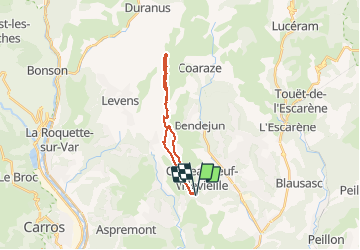
Trail Walking of 20 km to be discovered at Provence-Alpes-Côte d'Azur, Maritime Alps, Châteauneuf-Villevieille. This trail is proposed by aris.
Description
Départ du parking de Chateauneuf, la montée au Férion est assez longue par cet itinéraire. Sans difficulté (sauf peut-ètre un chemin mal tracé après Terre Forte.
Positioning
Country:
France
Region :
Provence-Alpes-Côte d'Azur
Department/Province :
Maritime Alps
Municipality :
Châteauneuf-Villevieille
Location:
Unknown
Start:(Dec)
Start:(UTM)
362661 ; 4851106 (32T) N.
Comments