


28 mars après midi

canal
User

Length
4.7 km

Max alt
172 m

Uphill gradient
72 m
Km-Effort
5.7 km

Min alt
127 m

Downhill gradient
72 m
Boucle
Yes
Creation date :
2021-03-27 15:24:23.17
Updated on :
2021-03-27 15:25:20.351
1h17
Difficulty : Easy

FREE GPS app for hiking
 SityTrail
IGN / Geographical institutes
SityTrail Plus
The world is yours!
About
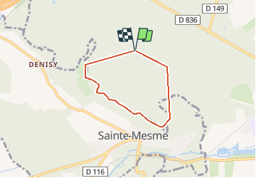
Trail Walking of 4.7 km to be discovered at Ile-de-France, Essonne, Dourdan. This trail is proposed by canal.
Positioning
Country:
France
Region :
Ile-de-France
Department/Province :
Essonne
Municipality :
Dourdan
Location:
Unknown
Start:(Dec)
Start:(UTM)
423339 ; 5377429 (31U) N.
Comments