


casque de l'heris

petit-pied
User
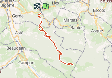

Length
16.7 km

Max alt
1524 m

Uphill gradient
830 m
Km-Effort
28 km

Min alt
811 m

Downhill gradient
830 m
Boucle
Yes
Creation date :
2021-03-27 09:30:59.867
Updated on :
2021-03-28 05:56:57.129
4h23
Difficulty : Easy

FREE GPS app for hiking
 SityTrail
IGN / Geographical institutes
SityTrail Plus
The world is yours!
About
Trail Walking of 16.7 km to be discovered at Occitania, Hautespyrenees, Gerde. This trail is proposed by petit-pied.
Positioning
Country:
France
Region :
Occitania
Department/Province :
Hautespyrenees
Municipality :
Gerde
Location:
Unknown
Start:(Dec)
Start:(UTM)
271510 ; 4771010 (31T) N.
Comments