


Lac de roue

nicogex
User
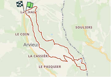

Length
11.3 km

Max alt
1927 m

Uphill gradient
375 m
Km-Effort
16.3 km

Min alt
1680 m

Downhill gradient
385 m
Boucle
Yes
Creation date :
2021-03-28 08:23:28.0
Updated on :
2021-03-28 11:38:51.868
3h15
Difficulty : Easy

FREE GPS app for hiking
 SityTrail
IGN / Geographical institutes
SityTrail Plus
The world is yours!
About
Trail Walking of 11.3 km to be discovered at Provence-Alpes-Côte d'Azur, Hautes-Alpes, Arvieux. This trail is proposed by nicogex.
Positioning
Country:
France
Region :
Provence-Alpes-Côte d'Azur
Department/Province :
Hautes-Alpes
Municipality :
Arvieux
Location:
Unknown
Start:(Dec)
Start:(UTM)
320899 ; 4961150 (32T) N.
Comments