


Coux/pouzin

raygautier
User
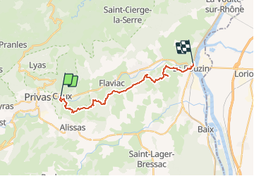

Length
18.7 km

Max alt
432 m

Uphill gradient
556 m
Km-Effort
27 km

Min alt
87 m

Downhill gradient
670 m
Boucle
No
Creation date :
2021-03-29 07:36:32.0
Updated on :
2021-03-29 15:24:49.822
7h47
Difficulty : Unknown

FREE GPS app for hiking
 SityTrail
IGN / Geographical institutes
SityTrail Plus
The world is yours!
About
Trail Walking of 18.7 km to be discovered at Auvergne-Rhône-Alpes, Ardèche, Coux. This trail is proposed by raygautier.
Positioning
Country:
France
Region :
Auvergne-Rhône-Alpes
Department/Province :
Ardèche
Municipality :
Coux
Location:
Unknown
Start:(Dec)
Start:(UTM)
628374 ; 4954886 (31T) N.
Comments