


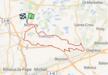
Mionnay-35km-298m

ThierryJ01
User

Length
35 km

Max alt
314 m

Uphill gradient
298 m
Km-Effort
39 km

Min alt
211 m

Downhill gradient
298 m
Boucle
Yes
Creation date :
2021-03-29 19:58:10.8
Updated on :
2021-03-29 20:03:10.183
2h41
Difficulty : Difficult

FREE GPS app for hiking
 SityTrail
IGN / Geographical institutes
SityTrail Plus
The world is yours!
About
Trail Mountain bike of 35 km to be discovered at Auvergne-Rhône-Alpes, Ain, Mionnay. This trail is proposed by ThierryJ01.
Positioning
Country:
France
Region :
Auvergne-Rhône-Alpes
Department/Province :
Ain
Municipality :
Mionnay
Location:
Unknown
Start:(Dec)
Start:(UTM)
649146 ; 5084458 (31T) N.
Comments