


Amicale_Loire_sur_Rhone_Burlat

d.rognon
User

Length
15.9 km

Max alt
486 m

Uphill gradient
478 m
Km-Effort
22 km

Min alt
160 m

Downhill gradient
483 m
Boucle
Yes
Creation date :
2021-03-31 09:03:25.076
Updated on :
2021-06-24 02:41:45.441
5h03
Difficulty : Very difficult

FREE GPS app for hiking
 SityTrail
IGN / Geographical institutes
SityTrail Plus
The world is yours!
About
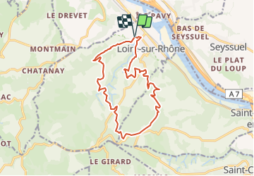
Trail Walking of 15.9 km to be discovered at Auvergne-Rhône-Alpes, Rhône, Loire-sur-Rhône. This trail is proposed by d.rognon.
Description
Randonnée effectuée le 20/06/21.
Beaucoup de trajet en sous-bois, ce qui est agréable lors des grosses chaleurs.
Positioning
Country:
France
Region :
Auvergne-Rhône-Alpes
Department/Province :
Rhône
Municipality :
Loire-sur-Rhône
Location:
Unknown
Start:(Dec)
Start:(UTM)
640366 ; 5047044 (31T) N.
Comments