


st fiacre-choloy

mannequ1
User
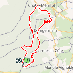

Length
18.6 km

Max alt
409 m

Uphill gradient
310 m
Km-Effort
23 km

Min alt
242 m

Downhill gradient
314 m
Boucle
Yes
Creation date :
2014-12-10 00:00:00.0
Updated on :
2014-12-10 00:00:00.0
3h56
Difficulty : Medium

FREE GPS app for hiking
 SityTrail
IGN / Geographical institutes
SityTrail Plus
The world is yours!
About
Trail Walking of 18.6 km to be discovered at Grand Est, Meuse, Rigny-Saint-Martin. This trail is proposed by mannequ1.
Photos


Positioning
Country:
France
Region :
Grand Est
Department/Province :
Meuse
Municipality :
Rigny-Saint-Martin
Location:
Unknown
Start:(Dec)
Start:(UTM)
706214 ; 5388265 (31U) N.
Comments