pet de l'âne 1 avril 21

ocharra
User
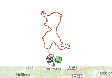

Length
38 km

Max alt
539 m

Uphill gradient
686 m
Km-Effort
47 km

Min alt
315 m

Downhill gradient
686 m
Boucle
Yes
Creation date :
2021-04-01 09:17:25.506
Updated on :
2021-04-01 13:19:38.31
2h43
Difficulty : Medium

FREE GPS app for hiking
 SityTrail
IGN / Geographical institutes
SityTrail Plus
The world is yours!
About
Trail Mountain bike of 38 km to be discovered at Auvergne-Rhône-Alpes, Loire, Pommiers-en-Forez. This trail is proposed by ocharra.
Positioning
Country:
France
Region :
Auvergne-Rhône-Alpes
Department/Province :
Loire
Municipality :
Pommiers-en-Forez
Location:
Unknown
Start:(Dec)
Start:(UTM)
582823 ; 5075577 (31T) N.
Comments