


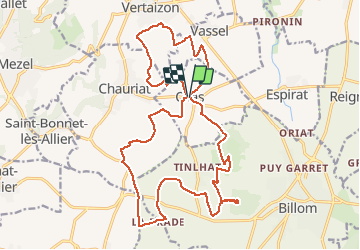
Chas le petit et le gros Turluron le puy Benoit le puy de Pileyre

jeanic63
User

Length
24 km

Max alt
552 m

Uphill gradient
696 m
Km-Effort
33 km

Min alt
346 m

Downhill gradient
693 m
Boucle
Yes
Creation date :
2021-04-02 09:40:16.12
Updated on :
2021-04-02 09:43:08.449
7h33
Difficulty : Difficult

FREE GPS app for hiking
 SityTrail
IGN / Geographical institutes
SityTrail Plus
The world is yours!
About
Trail On foot of 24 km to be discovered at Auvergne-Rhône-Alpes, Puy-de-Dôme, Chas. This trail is proposed by jeanic63.
Description
départ mairie de Chas
Positioning
Country:
France
Region :
Auvergne-Rhône-Alpes
Department/Province :
Puy-de-Dôme
Municipality :
Chas
Location:
Unknown
Start:(Dec)
Start:(UTM)
523470 ; 5066173 (31T) N.
Comments