


Semoutiers

janussity
User
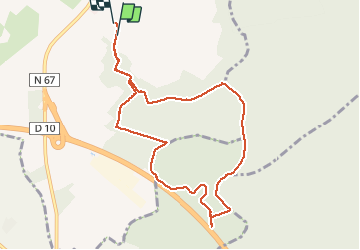

Length
8.9 km

Max alt
350 m

Uphill gradient
89 m
Km-Effort
10.1 km

Min alt
311 m

Downhill gradient
92 m
Boucle
Yes
Creation date :
2021-04-02 12:06:20.179
Updated on :
2021-04-02 14:29:37.088
2h05
Difficulty : Easy

FREE GPS app for hiking
 SityTrail
IGN / Geographical institutes
SityTrail Plus
The world is yours!
About
Trail Walking of 8.9 km to be discovered at Grand Est, Haute-Marne, Semoutiers-Montsaon. This trail is proposed by janussity.
Description
h.Vent soleil
Positioning
Country:
France
Region :
Grand Est
Department/Province :
Haute-Marne
Municipality :
Semoutiers-Montsaon
Location:
Unknown
Start:(Dec)
Start:(UTM)
654268 ; 5324117 (31U) N.
Comments