


rheme golete

m@nu
User
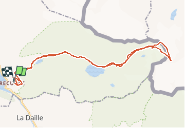

Length
23 km

Max alt
3249 m

Uphill gradient
1316 m
Km-Effort
41 km

Min alt
1914 m

Downhill gradient
1316 m
Boucle
Yes
Creation date :
2021-04-01 07:38:46.817
Updated on :
2021-04-02 15:04:09.228
8h39
Difficulty : Very easy

FREE GPS app for hiking
 SityTrail
IGN / Geographical institutes
SityTrail Plus
The world is yours!
About
Trail Touring skiing of 23 km to be discovered at Auvergne-Rhône-Alpes, Savoy, Tignes. This trail is proposed by m@nu.
Positioning
Country:
France
Region :
Auvergne-Rhône-Alpes
Department/Province :
Savoy
Municipality :
Tignes
Location:
Unknown
Start:(Dec)
Start:(UTM)
340155 ; 5037945 (32T) N.
Comments