


valisere

m@nu
User
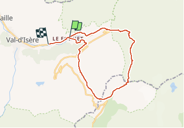

Length
15.2 km

Max alt
3007 m

Uphill gradient
1093 m
Km-Effort
30 km

Min alt
1878 m

Downhill gradient
1167 m
Boucle
No
Creation date :
2021-04-02 08:02:37.289
Updated on :
2021-04-02 15:04:10.979
6h37
Difficulty : Very easy

FREE GPS app for hiking
 SityTrail
IGN / Geographical institutes
SityTrail Plus
The world is yours!
About
Trail Touring skiing of 15.2 km to be discovered at Auvergne-Rhône-Alpes, Savoy, Val-d'Isère. This trail is proposed by m@nu.
Positioning
Country:
France
Region :
Auvergne-Rhône-Alpes
Department/Province :
Savoy
Municipality :
Val-d'Isère
Location:
Unknown
Start:(Dec)
Start:(UTM)
344577 ; 5034954 (32T) N.
Comments