


Le pont de chervil

raygautier
User

Length
17.6 km

Max alt
870 m

Uphill gradient
701 m
Km-Effort
27 km

Min alt
276 m

Downhill gradient
705 m
Boucle
Yes
Creation date :
2021-04-03 07:17:20.0
Updated on :
2021-04-03 14:33:57.795
7h15
Difficulty : Very difficult

FREE GPS app for hiking
 SityTrail
IGN / Geographical institutes
SityTrail Plus
The world is yours!
About
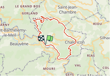
Trail Walking of 17.6 km to be discovered at Auvergne-Rhône-Alpes, Ardèche, Chalencon. This trail is proposed by raygautier.
Positioning
Country:
France
Region :
Auvergne-Rhône-Alpes
Department/Province :
Ardèche
Municipality :
Chalencon
Location:
Unknown
Start:(Dec)
Start:(UTM)
621628 ; 4970238 (31T) N.
Comments