


Cazals brousses

Glurps
User
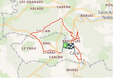

Length
16.8 km

Max alt
314 m

Uphill gradient
282 m
Km-Effort
21 km

Min alt
111 m

Downhill gradient
435 m
Boucle
No
Creation date :
2021-04-03 09:53:04.0
Updated on :
2021-04-03 14:40:39.768
4h21
Difficulty : Medium

FREE GPS app for hiking
 SityTrail
IGN / Geographical institutes
SityTrail Plus
The world is yours!
About
Trail Walking of 16.8 km to be discovered at Occitania, Tarn-et-Garonne, Cazals. This trail is proposed by Glurps.
Description
Ajouter 30 minutes de montée depuis cazals (on enregistrement)
Positioning
Country:
France
Region :
Occitania
Department/Province :
Tarn-et-Garonne
Municipality :
Cazals
Location:
Unknown
Start:(Dec)
Start:(UTM)
396101 ; 4886319 (31T) N.
Comments