Trail On foot Serpaize - Serpaize 1 - TL - 04/2021 - Photo

Serpaize 1 - TL - 04/2021

© OpenStreetMap contributors
Length
Length
10.9 km
Max alt
Max alt
310 m
Uphill gradient
Uphill gradient
223 m
Km-Effort
Km-Effort  
13.9 km
Min alt
Min alt
206 m
Downhill gradient
Downhill gradient
221 m
Boucle
Boucle
Yes
Creation date :
2021-04-03 18:06:09.013
Updated on :
2023-03-13 18:16:32.717

(1 Reviews)

On foot
On foot
2h53
Difficulty : Easy

Scan this QR Code to open this trail in the SityTrail application

FREE GPS app for hiking

Logo SityTrail SityTrail

IGN / Geographical institutes

Download SityTrail from the App Store Download SityTrail from Google Play

Logo SityTrail SityTrail World

The world is yours!

Download SityTrail from the App Store Download SityTrail from Google Play Download SityTrail on Huawei AppGallery

About

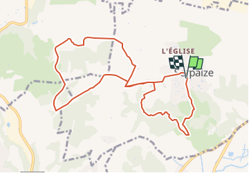
Trail On foot of 10.9 km to be discovered at Auvergne-Rhône-Alpes, Isère, Serpaize. This trail is proposed by Clubléorando.

Description

Départ parking de la mairie / Stade à Serpaize
10 km D = 210

Elevation profile

Positioning

Country:
France
Region :
Auvergne-Rhône-Alpes
Department/Province :
Isère
Municipality :
Serpaize
Location:
Unknown
Start:(UTM)
649713 ; 5046714 (31T) N.

Comments

Please log in to post a review or rate the element


Trails nearby

Trail Mountain bike Serpaize - canyon  de Serpaize - Photo
Mountain bike
marc6262

Mountain bike

Easy
(1)
Serpaize, Auvergne-Rhône-Alpes, Isère, France
13.4 km | 16.8 km-effort
1h 46min
Yes
Trail Hybrid bike Vienne - ViaRhona Vienne Coux 150km - Photo
Hybrid bike
GUIDE
thonyc

Hybrid bike

Medium
Vienne, Auvergne-Rhône-Alpes, Isère, France
146 km | 162 km-effort
Unknown
No
Trail Walking Vienne - 38-Vienne-visite-4.5km-mai21 - Photo
Walking
SyMA

Walking

Easy
Vienne, Auvergne-Rhône-Alpes, Isère, France
4.6 km | 5.2 km-effort
1h 47min
Yes
Trail Cycle Vienne - Via Rhona : Vienne St Rambert d'Albon  - Photo
Cycle
Toune73

Cycle

Very easy
(1)
Vienne, Auvergne-Rhône-Alpes, Isère, France
36 km | 39 km-effort
Unknown
No
Trail Walking Vienne - naïade nocturne digestive à Vienne - Isère - Photo
Walking
stef789

Walking

Very easy
Vienne, Auvergne-Rhône-Alpes, Isère, France
3 km | 3.6 km-effort
1h 38min
Yes
Trail Road bike Pont-Évêque - Pont-Évêque 47km - Photo
Road bike
sebcastella

Road bike

Very difficult
Pont-Évêque, Auvergne-Rhône-Alpes, Isère, France
47 km | 56 km-effort
3h 23min
Yes
Trail Walking Communay - balade notre dame de linon  - Photo
Walking
Swyn

Walking

Easy
Communay, Auvergne-Rhône-Alpes, Rhône, France
4.9 km | 7.2 km-effort
2h 7min
Yes
Trail On foot Vienne - Vienne est - les hauts par St Alban les Vignes - 10,1 km - 290 m de dénivelé - 3h30 - Photo
On foot
Clubléorando

On foot

Medium
Vienne, Auvergne-Rhône-Alpes, Isère, France
10.1 km | 14 km-effort
3h 30min
Yes
Trail On foot Luzinay - Chapelle d'Illins 01-24 / TL - Photo
On foot
Clubléorando

On foot

Easy
Luzinay, Auvergne-Rhône-Alpes, Isère, France
10.5 km | 13.4 km-effort
3h 3min
Yes


Close
My subscriptions