


De l’écluse de choignes à la passerelle

carolineF11
User
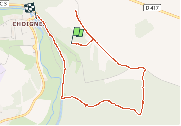

Length
5.2 km

Max alt
362 m

Uphill gradient
77 m
Km-Effort
6.5 km

Min alt
261 m

Downhill gradient
140 m
Boucle
No
Creation date :
2021-04-04 11:52:32.0
Updated on :
2021-04-04 14:00:15.568
1h34
Difficulty : Unknown

FREE GPS app for hiking
 SityTrail
IGN / Geographical institutes
SityTrail Plus
The world is yours!
About
Trail Walking of 5.2 km to be discovered at Grand Est, Haute-Marne, Chamarandes-Choignes. This trail is proposed by carolineF11.
Positioning
Country:
France
Region :
Grand Est
Department/Province :
Haute-Marne
Municipality :
Chamarandes-Choignes
Location:
Unknown
Start:(Dec)
Start:(UTM)
662152 ; 5330298 (31U) N.
Comments