


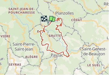
Faugères 16km

thonyc
User GUIDE

Length
15.8 km

Max alt
481 m

Uphill gradient
497 m
Km-Effort
22 km

Min alt
301 m

Downhill gradient
499 m
Boucle
Yes
Creation date :
2021-04-04 18:18:34.674
Updated on :
2021-04-14 17:20:22.255
5h42
Difficulty : Difficult

FREE GPS app for hiking
 SityTrail
IGN / Geographical institutes
SityTrail Plus
The world is yours!
About
Trail Walking of 15.8 km to be discovered at Auvergne-Rhône-Alpes, Ardèche, Faugères. This trail is proposed by thonyc.
Positioning
Country:
France
Region :
Auvergne-Rhône-Alpes
Department/Province :
Ardèche
Municipality :
Faugères
Location:
Unknown
Start:(Dec)
Start:(UTM)
590299 ; 4925286 (31T) N.
Comments