


2021-04-05_15h39m19_suarlee 2020-09-03__20200903_1355

sarriette
User
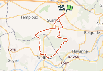

Length
13.1 km

Max alt
211 m

Uphill gradient
199 m
Km-Effort
15.8 km

Min alt
88 m

Downhill gradient
200 m
Boucle
Yes
Creation date :
2021-04-05 13:39:24.112
Updated on :
2021-04-05 13:39:23.567

FREE GPS app for hiking
 SityTrail
IGN / Geographical institutes
SityTrail Plus
The world is yours!
About
Trail of 13.1 km to be discovered at Wallonia, Namur, Namur. This trail is proposed by sarriette.
Positioning
Country:
Belgium
Region :
Wallonia
Department/Province :
Namur
Municipality :
Namur
Location:
Suarlée
Start:(Dec)
Start:(UTM)
627364 ; 5594129 (31U) N.
Comments