


Mionnay-38km-294m

ThierryJ01
User
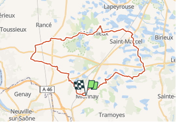

Length
38 km

Max alt
310 m

Uphill gradient
293 m
Km-Effort
42 km

Min alt
276 m

Downhill gradient
293 m
Boucle
Yes
Creation date :
2021-04-05 21:16:59.888
Updated on :
2021-05-30 19:23:10.652
2h53
Difficulty : Very difficult

FREE GPS app for hiking
 SityTrail
IGN / Geographical institutes
SityTrail Plus
The world is yours!
About
Trail Mountain bike of 38 km to be discovered at Auvergne-Rhône-Alpes, Ain, Mionnay. This trail is proposed by ThierryJ01.
Description
Sur la deuxième partie majoritairement sur goudron
Positioning
Country:
France
Region :
Auvergne-Rhône-Alpes
Department/Province :
Ain
Municipality :
Mionnay
Location:
Unknown
Start:(Dec)
Start:(UTM)
649714 ; 5084245 (31T) N.
Comments