


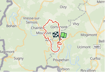
Rochehaut ; crêtes de Frahan ; Alle ; Mouzaive ; Gros Fays ; Cornimont ; retour Rochehaut

Beranger Guillaume
User

Length
19.5 km

Max alt
429 m

Uphill gradient
894 m
Km-Effort
31 km

Min alt
184 m

Downhill gradient
880 m
Boucle
Yes
Creation date :
2021-04-06 07:48:00.423
Updated on :
2021-04-06 14:28:10.318
5h56
Difficulty : Very difficult

FREE GPS app for hiking
 SityTrail
IGN / Geographical institutes
SityTrail Plus
The world is yours!
About
Trail Walking of 19.5 km to be discovered at Wallonia, Luxembourg, Bouillon. This trail is proposed by Beranger Guillaume.
Description
boucle en plein coeur de la vallée de la semois
Positioning
Country:
Belgium
Region :
Wallonia
Department/Province :
Luxembourg
Municipality :
Bouillon
Location:
Rochehaut
Start:(Dec)
Start:(UTM)
643795 ; 5522749 (31U) N.
Comments