


entre-marcoussis-et-l-orge2

gdela
User

Length
21 km

Max alt
169 m

Uphill gradient
331 m
Km-Effort
25 km

Min alt
36 m

Downhill gradient
333 m
Boucle
Yes
Creation date :
2021-04-06 15:44:55.903
Updated on :
2021-04-06 16:29:06.192
5h42
Difficulty : Very difficult

FREE GPS app for hiking
 SityTrail
IGN / Geographical institutes
SityTrail Plus
The world is yours!
About
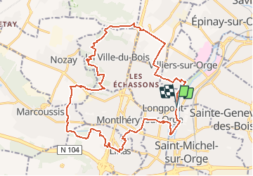
Trail Walking of 21 km to be discovered at Ile-de-France, Essonne, Longpont-sur-Orge. This trail is proposed by gdela.
Description
Distance21 km - Km Effort 25 km
Altitude min 36 m
Altitude max 169 m
Dénivelé positif 331 m
Dénivelé négatif 333 m
Positioning
Country:
France
Region :
Ile-de-France
Department/Province :
Essonne
Municipality :
Longpont-sur-Orge
Location:
Unknown
Start:(Dec)
Start:(UTM)
448259 ; 5388193 (31U) N.
Comments