


SityTrail - Anthines - AS03 - Boucle de Tolumont - Losange Bleu

Alfredy
User GUIDE
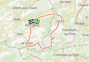

Length
13.9 km

Max alt
280 m

Uphill gradient
320 m
Km-Effort
18.2 km

Min alt
182 m

Downhill gradient
327 m
Boucle
Yes
Creation date :
2021-04-08 13:38:48.443
Updated on :
2025-01-07 14:09:47.83
4h08
Difficulty : Easy

FREE GPS app for hiking
 SityTrail
IGN / Geographical institutes
SityTrail Plus
The world is yours!
About
Trail On foot of 13.9 km to be discovered at Wallonia, Liège, Anthisnes. This trail is proposed by Alfredy.
Description
Suivez le balisage Losange Bleu.
Très agréable randonnée d'environ 3 heures.
Positioning
Country:
Belgium
Region :
Wallonia
Department/Province :
Liège
Municipality :
Anthisnes
Location:
Unknown
Start:(Dec)
Start:(UTM)
679100 ; 5595019 (31U) N.
Comments