


visugpx_2GiDVXOKlJ

jeanboulay
User
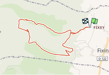

Length
5.4 km

Max alt
462 m

Uphill gradient
194 m
Km-Effort
8 km

Min alt
324 m

Downhill gradient
194 m
Boucle
Yes
Creation date :
2021-04-08 16:23:34.458
Updated on :
2021-04-08 16:28:18.961
1h48
Difficulty : Medium

FREE GPS app for hiking
 SityTrail
IGN / Geographical institutes
SityTrail Plus
The world is yours!
About
Trail Walking of 5.4 km to be discovered at Bourgogne-Franche-Comté, Côte-d'Or, Fixin. This trail is proposed by jeanboulay.
Positioning
Country:
France
Region :
Bourgogne-Franche-Comté
Department/Province :
Côte-d'Or
Municipality :
Fixin
Location:
Unknown
Start:(Dec)
Start:(UTM)
649011 ; 5234818 (31T) N.
Comments