


Le village jusqu’au pont SNCF

babouille
User

Length
4 km

Max alt
641 m

Uphill gradient
49 m
Km-Effort
4.6 km

Min alt
605 m

Downhill gradient
51 m
Boucle
Yes
Creation date :
2021-04-09 06:26:08.0
Updated on :
2021-04-09 07:35:00.839
1h06
Difficulty : Unknown

FREE GPS app for hiking
 SityTrail
IGN / Geographical institutes
SityTrail Plus
The world is yours!
About
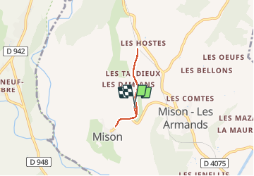
Trail Walking of 4 km to be discovered at Provence-Alpes-Côte d'Azur, Alpes-de-Haute-Provence, Mison. This trail is proposed by babouille.
Positioning
Country:
France
Region :
Provence-Alpes-Côte d'Azur
Department/Province :
Alpes-de-Haute-Provence
Municipality :
Mison
Location:
Unknown
Start:(Dec)
Start:(UTM)
727217 ; 4905667 (31T) N.
Comments