


2021-04-09_19h13m35_saint pierre de colombier ruge

raab
User
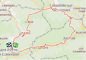

Length
13.2 km

Max alt
863 m

Uphill gradient
636 m
Km-Effort
22 km

Min alt
401 m

Downhill gradient
636 m
Boucle
Yes
Creation date :
2021-04-09 17:13:35.839
Updated on :
2021-04-10 09:59:36.949
4h55
Difficulty : Medium

FREE GPS app for hiking
 SityTrail
IGN / Geographical institutes
SityTrail Plus
The world is yours!
About
Trail On foot of 13.2 km to be discovered at Auvergne-Rhône-Alpes, Ardèche, Saint-Pierre-de-Colombier. This trail is proposed by raab.
Positioning
Country:
France
Region :
Auvergne-Rhône-Alpes
Department/Province :
Ardèche
Municipality :
Saint-Pierre-de-Colombier
Location:
Unknown
Start:(Dec)
Start:(UTM)
600177 ; 4950902 (31T) N.
Comments