


Boucle par les tennis de choignes

carolineF11
User
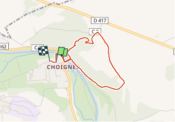

Length
3.4 km

Max alt
345 m

Uphill gradient
92 m
Km-Effort
4.6 km

Min alt
256 m

Downhill gradient
91 m
Boucle
Yes
Creation date :
2021-04-10 06:43:12.0
Updated on :
2021-04-10 07:31:38.382
47m
Difficulty : Easy

FREE GPS app for hiking
 SityTrail
IGN / Geographical institutes
SityTrail Plus
The world is yours!
About
Trail Walking of 3.4 km to be discovered at Grand Est, Haute-Marne, Chamarandes-Choignes. This trail is proposed by carolineF11.
Positioning
Country:
France
Region :
Grand Est
Department/Province :
Haute-Marne
Municipality :
Chamarandes-Choignes
Location:
Unknown
Start:(Dec)
Start:(UTM)
661509 ; 5330599 (31U) N.
Comments