


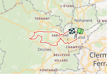
Durtol la cote de Pegnu modifiée 13km

jeanic63
User

Length
13.5 km

Max alt
989 m

Uphill gradient
486 m
Km-Effort
20 km

Min alt
532 m

Downhill gradient
491 m
Boucle
Yes
Creation date :
2021-04-11 16:31:42.858
Updated on :
2021-05-26 19:30:52.549
4h31
Difficulty : Difficult

FREE GPS app for hiking
 SityTrail
IGN / Geographical institutes
SityTrail Plus
The world is yours!
About
Trail On foot of 13.5 km to be discovered at Auvergne-Rhône-Alpes, Puy-de-Dôme, Durtol. This trail is proposed by jeanic63.
Description
départ gare de Durtol
Positioning
Country:
France
Region :
Auvergne-Rhône-Alpes
Department/Province :
Puy-de-Dôme
Municipality :
Durtol
Location:
Unknown
Start:(Dec)
Start:(UTM)
503722 ; 5071252 (31T) N.
Comments