


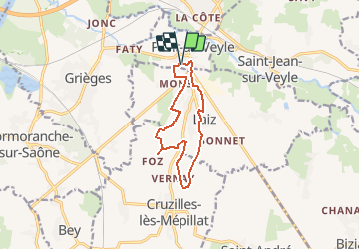
FOZ par Laiz

janussity
User

Length
10.2 km

Max alt
206 m

Uphill gradient
85 m
Km-Effort
11.4 km

Min alt
172 m

Downhill gradient
86 m
Boucle
Yes
Creation date :
2021-04-13 12:48:37.907
Updated on :
2021-04-13 12:50:29.61
2h34
Difficulty : Easy

FREE GPS app for hiking
 SityTrail
IGN / Geographical institutes
SityTrail Plus
The world is yours!
About
Trail On foot of 10.2 km to be discovered at Auvergne-Rhône-Alpes, Ain, Pont-de-Veyle. This trail is proposed by janussity.
Description
Chemins et routes
Positioning
Country:
France
Region :
Auvergne-Rhône-Alpes
Department/Province :
Ain
Municipality :
Pont-de-Veyle
Location:
Unknown
Start:(Dec)
Start:(UTM)
645223 ; 5124583 (31T) N.
Comments