


Besançon 12 avril 2021(IBP 90) CAF

TRIMAILLE
User

Length
24 km

Max alt
501 m

Uphill gradient
869 m
Km-Effort
35 km

Min alt
231 m

Downhill gradient
869 m
Boucle
Yes
Creation date :
2021-04-13 15:10:16.492
Updated on :
2021-04-13 15:50:37.234
6h34
Difficulty : Difficult

FREE GPS app for hiking
 SityTrail
IGN / Geographical institutes
SityTrail Plus
The world is yours!
About
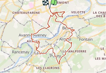
Trail Walking of 24 km to be discovered at Bourgogne-Franche-Comté, Doubs, Besançon. This trail is proposed by TRIMAILLE.
Description
Départ parking de la Malcombe. Rosemont, fort de Planoise, Avanne, rocher de Valmy, Larnod, Pugey, fort Rolland,Arguel, Beure.
Positioning
Country:
France
Region :
Bourgogne-Franche-Comté
Department/Province :
Doubs
Municipality :
Besançon
Location:
Unknown
Start:(Dec)
Start:(UTM)
725893 ; 5234213 (31T) N.
Comments