


Tavel par la route de Rochefort

Bredu
User
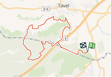

Length
12.1 km

Max alt
196 m

Uphill gradient
226 m
Km-Effort
15.1 km

Min alt
83 m

Downhill gradient
226 m
Boucle
Yes
Creation date :
2021-04-14 10:02:05.652
Updated on :
2021-04-14 10:03:45.325
3h26
Difficulty : Difficult

FREE GPS app for hiking
 SityTrail
IGN / Geographical institutes
SityTrail Plus
The world is yours!
About
Trail Walking of 12.1 km to be discovered at Occitania, Gard, Tavel. This trail is proposed by Bredu.
Positioning
Country:
France
Region :
Occitania
Department/Province :
Gard
Municipality :
Tavel
Location:
Unknown
Start:(Dec)
Start:(UTM)
637236 ; 4872618 (31T) N.
Comments