


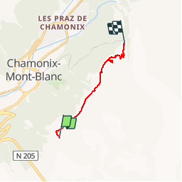
Chamonix.. Bob G...Le Plan de l'Aiguille vers le Montenvers..

r.genette
User


3h20
Difficulty : Medium

FREE GPS app for hiking
 SityTrail
IGN / Geographical institutes
SityTrail Plus
The world is yours!
About
Trail Walking of 6.6 km to be discovered at Auvergne-Rhône-Alpes, Upper Savoy, Chamonix-Mont-Blanc. This trail is proposed by r.genette.
Description
Grand Balcon Nord depuis le Plan de l'Aiguille vers le Montenvers en passant par le Signal de Forbes...Point de vue magnifique sur la Mer de Glace et tous les sommets mythiques de la chaîne du Mont Blanc
Positioning
Comments