


sjdll apigne 2

ballay
User
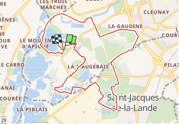

Length
11.9 km

Max alt
40 m

Uphill gradient
86 m
Km-Effort
13.1 km

Min alt
18 m

Downhill gradient
87 m
Boucle
Yes
Creation date :
2021-04-14 16:31:12.581
Updated on :
2021-04-14 16:31:54.943
2h58
Difficulty : Easy

FREE GPS app for hiking
 SityTrail
IGN / Geographical institutes
SityTrail Plus
The world is yours!
About
Trail On foot of 11.9 km to be discovered at Brittany, Ille-et-Vilaine, Rennes. This trail is proposed by ballay.
Positioning
Country:
France
Region :
Brittany
Department/Province :
Ille-et-Vilaine
Municipality :
Rennes
Location:
Quartiers Ouest
Start:(Dec)
Start:(UTM)
593980 ; 5327380 (30U) N.
Comments