


Illat

janussity
User

Length
4.9 km

Max alt
251 m

Uphill gradient
59 m
Km-Effort
5.7 km

Min alt
223 m

Downhill gradient
59 m
Boucle
Yes
Creation date :
2021-04-14 15:16:22.989
Updated on :
2021-04-14 16:35:59.582
1h15
Difficulty : Easy

FREE GPS app for hiking
 SityTrail
IGN / Geographical institutes
SityTrail Plus
The world is yours!
About
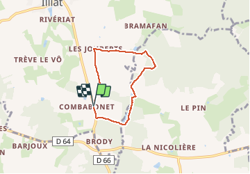
Trail Walking of 4.9 km to be discovered at Auvergne-Rhône-Alpes, Ain, Illiat. This trail is proposed by janussity.
Description
Vent soleil et fraicheur
Jolis étangs, mais privés.
Positioning
Country:
France
Region :
Auvergne-Rhône-Alpes
Department/Province :
Ain
Municipality :
Illiat
Location:
Unknown
Start:(Dec)
Start:(UTM)
646572 ; 5114730 (31T) N.
Comments