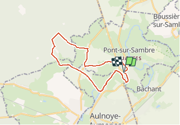
La Sambre à POnt sur Sambre

BrassensJC
User

Length
12.7 km

Max alt
175 m

Uphill gradient
106 m
Km-Effort
14.1 km

Min alt
124 m

Downhill gradient
107 m
Boucle
Yes
Creation date :
2021-04-18 08:15:22.528
Updated on :
2021-04-18 08:16:01.56
3h12
Difficulty : Difficult

FREE GPS app for hiking
 SityTrail
IGN / Geographical institutes
SityTrail Plus
The world is yours!
About
Trail Walking of 12.7 km to be discovered at Hauts-de-France, Nord, Pont-sur-Sambre. This trail is proposed by BrassensJC.
Positioning
Country:
France
Region :
Hauts-de-France
Department/Province :
Nord
Municipality :
Pont-sur-Sambre
Location:
Unknown
Start:(Dec)
Start:(UTM)
560385 ; 5563578 (31U) N.
Comments