


EOSEINE 2021

Tollard
User
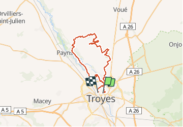

Length
50 km

Max alt
224 m

Uphill gradient
506 m
Km-Effort
56 km

Min alt
90 m

Downhill gradient
505 m
Boucle
No
Creation date :
2021-04-18 06:21:29.653
Updated on :
2021-04-18 10:05:58.602
3h43
Difficulty : Medium

FREE GPS app for hiking
 SityTrail
IGN / Geographical institutes
SityTrail Plus
The world is yours!
About
Trail Mountain bike of 50 km to be discovered at Grand Est, Aube, Troyes. This trail is proposed by Tollard.
Description
le meilleur concentré Seine Eolienne, bravo Daniel
Positioning
Country:
France
Region :
Grand Est
Department/Province :
Aube
Municipality :
Troyes
Location:
Unknown
Start:(Dec)
Start:(UTM)
580084 ; 5350997 (31U) N.
Comments