


marcouray

dhouet
User
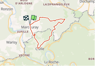

Length
11.7 km

Max alt
555 m

Uphill gradient
335 m
Km-Effort
16.2 km

Min alt
271 m

Downhill gradient
336 m
Boucle
Yes
Creation date :
2021-04-18 08:07:16.308
Updated on :
2021-04-18 11:01:12.483
2h53
Difficulty : Difficult

FREE GPS app for hiking
 SityTrail
IGN / Geographical institutes
SityTrail Plus
The world is yours!
About
Trail Walking of 11.7 km to be discovered at Wallonia, Luxembourg, Rendeux. This trail is proposed by dhouet.
Positioning
Country:
Belgium
Region :
Wallonia
Department/Province :
Luxembourg
Municipality :
Rendeux
Location:
Marcourt
Start:(Dec)
Start:(UTM)
681777 ; 5565677 (31U) N.
Comments
Idéale pour combler un besoin de forêt, de calme, de sérénité.