


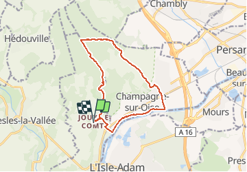
Jouy Oise Champagne Lay

avdem
User

Length
12.6 km

Max alt
146 m

Uphill gradient
189 m
Km-Effort
15.1 km

Min alt
20 m

Downhill gradient
190 m
Boucle
Yes
Creation date :
2021-04-20 07:00:13.72
Updated on :
2021-04-20 09:49:44.461
2h48
Difficulty : Difficult

FREE GPS app for hiking
 SityTrail
IGN / Geographical institutes
SityTrail Plus
The world is yours!
About
Trail Walking of 12.6 km to be discovered at Ile-de-France, Val-d'Oise, Parmain. This trail is proposed by avdem.
Description
tres bien
Photos

Positioning
Country:
France
Region :
Ile-de-France
Department/Province :
Val-d'Oise
Municipality :
Parmain
Location:
Unknown
Start:(Dec)
Start:(UTM)
442138 ; 5441949 (31U) N.
Comments