


Rochehaut mouzaive Cornimont Rochehaut

Beranger Guillaume
User
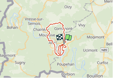

Length
23 km

Max alt
429 m

Uphill gradient
1040 m
Km-Effort
37 km

Min alt
184 m

Downhill gradient
1027 m
Boucle
Yes
Creation date :
2021-04-20 06:20:25.104
Updated on :
2021-04-20 11:57:22.92
5h35
Difficulty : Very difficult

FREE GPS app for hiking
 SityTrail
IGN / Geographical institutes
SityTrail Plus
The world is yours!
About
Trail Walking of 23 km to be discovered at Wallonia, Luxembourg, Bouillon. This trail is proposed by Beranger Guillaume.
Description
belles montées
Positioning
Country:
Belgium
Region :
Wallonia
Department/Province :
Luxembourg
Municipality :
Bouillon
Location:
Rochehaut
Start:(Dec)
Start:(UTM)
643805 ; 5522746 (31U) N.
Comments