


Brignais - Soucieux - Chaponost

JacouBrijou
User
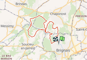

Length
17.8 km

Max alt
324 m

Uphill gradient
362 m
Km-Effort
23 km

Min alt
215 m

Downhill gradient
364 m
Boucle
Yes
Creation date :
2021-04-20 08:05:24.028
Updated on :
2021-04-20 14:02:08.945
5h55
Difficulty : Medium

FREE GPS app for hiking
 SityTrail
IGN / Geographical institutes
SityTrail Plus
The world is yours!
About
Trail Walking of 17.8 km to be discovered at Auvergne-Rhône-Alpes, Rhône, Brignais. This trail is proposed by JacouBrijou.
Description
18 km
Positioning
Country:
France
Region :
Auvergne-Rhône-Alpes
Department/Province :
Rhône
Municipality :
Brignais
Location:
Unknown
Start:(Dec)
Start:(UTM)
636113 ; 5059994 (31T) N.
Comments