Trail Walking Boulbon - Boulbon Vallon des Cavaillonès - Photo
 Manoune
Manoune

User

© OpenStreetMap contributors
Length
Length
16.6 km
Max alt
Max alt
153 m
Uphill gradient
Uphill gradient
273 m
Km-Effort
Km-Effort  
20 km
Min alt
Min alt
16 m
Downhill gradient
Downhill gradient
274 m
Boucle
Boucle
Yes
Creation date :
2021-04-20 07:03:19.983
Updated on :
2021-04-22 07:20:54.453

(0 Reviews)

Walking
Walking
5h40
Difficulty : Medium

Scan this QR Code to open this trail in the SityTrail application

FREE GPS app for hiking

Logo SityTrail SityTrail

IGN / Geographical institutes

Download SityTrail from the App Store Download SityTrail from Google Play

Logo SityTrail SityTrail World

The world is yours!

Download SityTrail from the App Store Download SityTrail from Google Play Download SityTrail on Huawei AppGallery

About

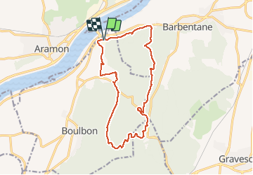
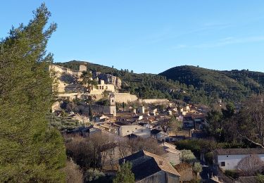
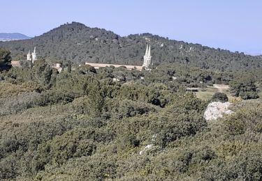
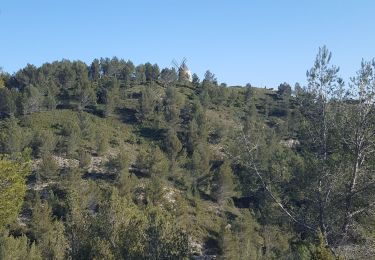
Trail Walking of 16.6 km to be discovered at Provence-Alpes-Côte d'Azur, Bouches-du-Rhône, Boulbon. This trail is proposed by Manoune.

Description

Départ de la zone du Colombier de Boulbon. Mas Livent, ligne haute tension, Cadeneau, Suivre des crêtes, parking de Frigolet, Rochers de Raous, Vallon des Cavaillonès, problème au petit mas de Grès, La Cantarelle, Carrières de Brun, Parking. Belle randonnée, à part la petite partie au niveau du Mas de Grès.
Attention ,beaucoup de chemin , suivre le GPS, sur les crêtes suivre des points rouge ou vert.

Elevation profile

Photos

Positioning

Country:
France
Region :
Provence-Alpes-Côte d'Azur
Department/Province :
Bouches-du-Rhône
Municipality :
Boulbon
Location:
Unknown
Start:(UTM)
637107 ; 4861484 (31T) N.

Trails nearby

Trail Walking Boulbon - Boulbon PR40 - Photo
Walking
DoBelle

Walking

Medium
(3)
Boulbon, Provence-Alpes-Côte d'Azur, Bouches-du-Rhône, France
16.9 km | 21 km-effort
3h 56min
Yes
Trail Walking Aramon - Les Castillones  - Photo
Walking
GUIDE
nadinebondoux

Walking

Medium
Aramon, Occitania, Gard, France
17.7 km | 23 km-effort
4h 29min
Yes
Trail Walking Boulbon - Boulbon Barbentane Frigolet  - Photo
Walking
GUIDE
nadinebondoux

Walking

Medium
Boulbon, Provence-Alpes-Côte d'Azur, Bouches-du-Rhône, France
19.6 km | 25 km-effort
5h 53min
Yes
Trail On foot Boulbon - Boulbon et le Moulin Bonnet - Photo
On foot
PatCoria

On foot

Easy
(2)
Boulbon, Provence-Alpes-Côte d'Azur, Bouches-du-Rhône, France
6.5 km | 8.6 km-effort
2h 20min
Yes
Trail Walking Barbentane - Barbentane  La Tour de Guet - Photo
Walking
Manoune

Walking

Medium
Barbentane, Provence-Alpes-Côte d'Azur, Bouches-du-Rhône, France
14.2 km | 18 km-effort
5h 30min
Yes
Trail Walking Tarascon - de l abbaye de frigolet à boulbon  - Photo
Walking
Coryphene

Walking

Medium
Tarascon, Provence-Alpes-Côte d'Azur, Bouches-du-Rhône, France
8.9 km | 11.8 km-effort
2h 49min
Yes
Trail Walking Tarascon - FRIGOLET Gratte Semelle - Photo
Walking
Manoune

Walking

Medium
Tarascon, Provence-Alpes-Côte d'Azur, Bouches-du-Rhône, France
14.8 km | 18.1 km-effort
5h 18min
Yes
Trail Walking Boulbon - Boulbon Moulin Montagnette  - Photo
Walking
vl84

Walking

Medium
Boulbon, Provence-Alpes-Côte d'Azur, Bouches-du-Rhône, France
6.5 km | 8.2 km-effort
2h 12min
Yes
Trail Walking Boulbon - frigolet-départ Rock d'acier.  - Photo
Walking
Altet

Walking

Very easy
(2)
Boulbon, Provence-Alpes-Côte d'Azur, Bouches-du-Rhône, France
16.2 km | 19.8 km-effort
3h 57min
Yes


Close
My subscriptions