


2021-04-21_14h29m28_2684447 - fosseuse-anservkille

avdem
User
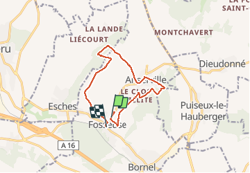

Length
11.4 km

Max alt
148 m

Uphill gradient
142 m
Km-Effort
13.4 km

Min alt
54 m

Downhill gradient
156 m
Boucle
No
Creation date :
2021-04-21 12:29:30.426
Updated on :
2021-04-21 12:29:32.921

FREE GPS app for hiking
 SityTrail
IGN / Geographical institutes
SityTrail Plus
The world is yours!
About
Trail of 11.4 km to be discovered at Hauts-de-France, Oise, Bornel. This trail is proposed by avdem.
Description
beau
Positioning
Country:
France
Region :
Hauts-de-France
Department/Province :
Oise
Municipality :
Bornel
Location:
Unknown
Start:(Dec)
Start:(UTM)
441141 ; 5451530 (31U) N.
Comments