


210421_evan_5_5_fouillet

d.rognon
User
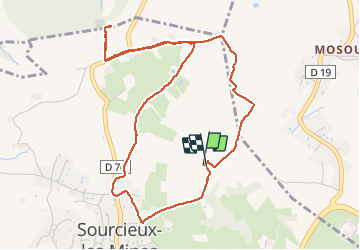

Length
5.5 km

Max alt
501 m

Uphill gradient
138 m
Km-Effort
7.4 km

Min alt
387 m

Downhill gradient
145 m
Boucle
Yes
Creation date :
2021-04-21 12:04:37.308
Updated on :
2021-04-21 15:06:03.638
1h49
Difficulty : Easy

FREE GPS app for hiking
 SityTrail
IGN / Geographical institutes
SityTrail Plus
The world is yours!
About
Trail Walking of 5.5 km to be discovered at Auvergne-Rhône-Alpes, Rhône, Sourcieux-les-Mines. This trail is proposed by d.rognon.
Positioning
Country:
France
Region :
Auvergne-Rhône-Alpes
Department/Province :
Rhône
Municipality :
Sourcieux-les-Mines
Location:
Unknown
Start:(Dec)
Start:(UTM)
626661 ; 5074106 (31T) N.
Comments