


Le grand 8 de Montaut

Emmanuelle Benoit
User
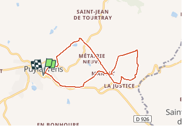

Length
8.3 km

Max alt
377 m

Uphill gradient
240 m
Km-Effort
11.5 km

Min alt
237 m

Downhill gradient
240 m
Boucle
Yes
Creation date :
2021-04-21 11:58:28.533
Updated on :
2021-04-21 15:12:16.024
2h57
Difficulty : Medium

FREE GPS app for hiking
 SityTrail
IGN / Geographical institutes
SityTrail Plus
The world is yours!
About
Trail Walking of 8.3 km to be discovered at Occitania, Tarn, Puylaurens. This trail is proposed by Emmanuelle Benoit.
Description
Randonnée agréable
Photos

Positioning
Country:
France
Region :
Occitania
Department/Province :
Tarn
Municipality :
Puylaurens
Location:
Unknown
Start:(Dec)
Start:(UTM)
420342 ; 4824721 (31T) N.
Comments