


Fournet Blancheroche Le Refrain (IBP87) 22 avril 2021 CAF

TRIMAILLE
User

Length
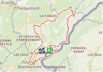
22 km

Max alt
1021 m

Uphill gradient
893 m
Km-Effort
34 km

Min alt
608 m

Downhill gradient
891 m
Boucle
Yes
Creation date :
2021-04-22 16:31:42.344
Updated on :
2021-04-27 13:47:38.268
6h20
Difficulty : Difficult

FREE GPS app for hiking
 SityTrail
IGN / Geographical institutes
SityTrail Plus
The world is yours!
About
Trail Walking of 22 km to be discovered at Bourgogne-Franche-Comté, Doubs, Fournet-Blancheroche. This trail is proposed by TRIMAILLE.
Description
Départ du parking du barrage du Refrain. Agréable randonnée mais exigeante. Parcours variés, belvédères, crêtes, gorges du Doubs....
Photos
 22 avril 2021 CAF - Photo 1")
 22 avril 2021 CAF - Photo 2")
Positioning
Country:
France
Region :
Bourgogne-Franche-Comté
Department/Province :
Doubs
Municipality :
Fournet-Blancheroche
Location:
Unknown
Start:(Dec)
Start:(UTM)
336790 ; 5226768 (32T) N.
Comments