


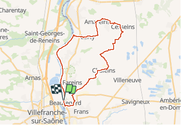
autour beauregard

jpfrobert
User

Length
31 km

Max alt
276 m

Uphill gradient
290 m
Km-Effort
35 km

Min alt
165 m

Downhill gradient
292 m
Boucle
Yes
Creation date :
2021-04-23 09:15:56.52
Updated on :
2021-04-23 09:16:41.391
2h26
Difficulty : Difficult

FREE GPS app for hiking
 SityTrail
IGN / Geographical institutes
SityTrail Plus
The world is yours!
About
Trail Mountain bike of 31 km to be discovered at Auvergne-Rhône-Alpes, Ain, Beauregard. This trail is proposed by jpfrobert.
Positioning
Country:
France
Region :
Auvergne-Rhône-Alpes
Department/Province :
Ain
Municipality :
Beauregard
Location:
Unknown
Start:(Dec)
Start:(UTM)
635499 ; 5095777 (31T) N.
Comments